Precision Aerial Survey and Imaging for Mobile, Alabama
Strategic Aerial Insight in Alabama
For any form of aerial survey required in Alabama, including advanced magnetometer and electromagnetic surveys, precision LiDAR mapping, and comprehensive GIS data acquisition, Mobile Helicopter Charters provides a wide array of specialized options. Our capabilities leverage the unique low-altitude and hover proficiencies of helicopters to ensure unparalleled data accuracy and coverage. Additionally, we specialize in high-definition aerial filming services, providing access to cutting-edge cinematography and photography technology. This includes options for specialized mounts or even door-off configurations for hand-held operations, ensuring your visual media projects capture Alabama from an optimal perspective.

Aerial
Surveys
LiDAR, GIS Maps, FLIR, HD Video & More
Mobile Helicopter Charters specializes in comprehensive infrastructure inspection and patrol services. From precise pipeline surveys and right-of-way inspections to critical transmission line patrols, we provide the optimal aircraft and specialized equipment required for accurate data acquisition. Our focus is on delivering efficient and effective solutions, ensuring your projects are executed with precision and adherence to operational standards.
High Tech Results
The Top Pilots in Alabama, Today's Technology... Maximum Results.
Call 1-866-826-4826 Now!
Mobile Helicopter Charters provides the tools needed to complete your land surveys, utilizing the right equipment to provide the aerial photos that are often needed.
An effective aerial survey simplifies critical operations such as right-of-way and site inspections, the precise alteration of topographical data, or the acquisition of high-definition imagery for commercial projects across Alabama. Helicopter surveys offer the most efficient method for examining challenging terrain, detecting anomalies in pipelines, identifying issues with transmission lines, or capturing detailed video and photographic documentation of property. Mobile Helicopter Charters is equipped to develop customized photographic and remote sensing operations, engineered to maximize both technical precision and financial efficiency, ultimately delivering superior results for your objectives.
The inherent capabilities of a helicopter make it the ideal platform for aerial surveying. Unlike fixed-wing aircraft, which are often restricted by FAA regulations to altitudes of 1,000 feet or more above the highest obstacle, helicopters can operate at significantly lower altitudes and maintain slower airspeeds. This unique maneuverability allows for highly detailed inspections and precise data collection. Furthermore, helicopters enable access to, and close examination of, hazardous or otherwise inaccessible zones, providing engineers and project managers with critical vantage points unattainable through other means.
There is no better way to conduct your visual survey, animal population counts, soil drainage analysis, ROW inspections, pipeline and transmission line inspections, and geographical surveys.

LiDAR Imaging
Light Detection and Ranging, or LiDAR, is a remote sensing method used to examine and measure Alabama topography as well as objects, like vegetation, upon it.

Infrared Imaging
Thermographic IR cameras are used to detect radiation in the long-infrared range of the electromagnetic spectrum and produce images of that radiation, called thermograms.
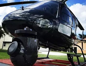
HD Video Gimbal Capture
Modern HD and 4K cameras can be mounted to helicopters, using the proper STCs, with a gimbal to stabilize photos & videos for detailed results.
Advanced Aerial Filming and Professional Cinematography
For expert camera work in the Mobile Sky
Get a Fast, free QuoteMobile Aerial Cinematography
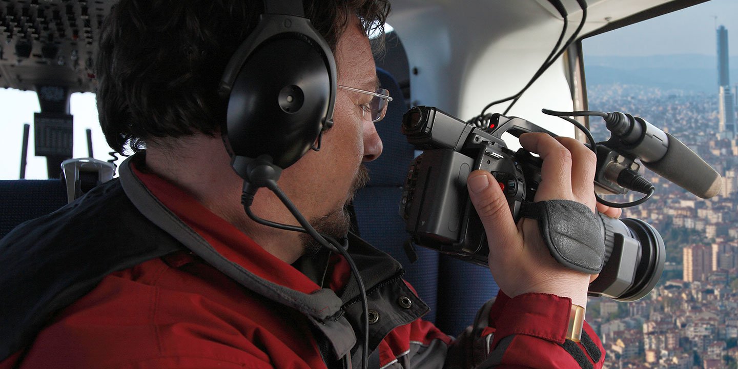
Mobile Helicopter Charters offers comprehensive access to the resources required for professional-grade aerial cinematography across Alabama. Our network provides cutting-edge technology for custom shoots, featuring gyro-stabilized camera mounts such as Tyler Mounts, Wescam, Cineflex, Pictorvision, and SpaceCam, integrated with high-performance cameras like Cineflex HD, RED Epic, and Arri Alexa, including specialized 3D and experimental systems. We support all facets of your production goals, from air-to-air to ground-to-air shots. Our experienced personnel collaborate closely with your aerial Directors of Photography and directors to achieve the precise visual results you envision. Specializing in helicopters for both still and motion photography, Mobile Helicopter Charters facilitates a broad spectrum of media-related operations in Alabama, including film, television, documentaries, promotional videos, commercials, aerial props, rapid relief work for television networks, and comprehensive coverage of historical and major sporting events, utilizing a diverse fleet of helicopters.
Call Us Today at 1-866-826-4826 for a Free Quote
Contact Us
Aerial Photos
Hand-held or Mounted OpTions in Mobile
We will help you get the right equipment for your aerial photography project! Call 1-866-826-4826 today to get a fast, free quote.
The Most Options for Photography
The breathtaking landscapes and unique settings of Alabama are best captured from an aerial perspective. Discover the unparalleled photographic opportunities available through our specialized aerial photography charters, designed to exceed your creative expectations and enable the precise visual capture you envision. Mobile Helicopter Charters is committed to providing clients with cost-effective photographic solutions of this caliber throughout Alabama. Many helicopters can be configured with the door removed for handheld projects, and we also provide information on advanced gyro-stabilized mounts to ensure optimal stability and professional-grade results.
Superior Service
Every one of our customers gets a dedicated helicopter expert to assist with flight plans, tech loadouts, production logistics, project schedules, and other demands.
Over 500 Aircraft
Our network of direct air partners extends well beyond Mobile, Alabama. This allows us to offer a wide range of solutions for even the most sophisticated projects.
The Best Equipment
From high-tech sensors like LiDAR, FLIR, and GIS to HD cameras and movie production gimbals, we're here to make your job as easy as possible.